Thomas Gallwey
I saw the summer sun go down behind the sea,
And o’er the pale moon grow a golden light,
From lonely Caran-tual’s topmost height
Towering aloft in cloudless majesty;
The serried hills beneath seem in the night
Like billowy ocean, having in its might
And turned to stone; while far as eye can see
The lengthening shadows o’ver the surface flee.

The mountains of the MacGillycuddy’s Reeks are rather special, not just in shape and form, but also in height, for they are home to the highest peaks in Ireland. Named after Cuddy, the servant or son of a local landlord, these lofty summits are linked by a ridge that stretches for miles from Kate Kearney’s Cottage to Lough Acoose. No other mountain range in Ireland even comes close to the grandeur of the Reeks ridge: it is home to nine out of the ten highest summits in the country, all of which reach Munro standards (those exclusive summits over 3,000 feet in Scotland named after Sir Hugh Munro). But out of all its tops, there’s one that attracts the most visitors, the pinnacle of their dreams. This is the summit of Carrauntoohil (1,040m/3,412ft), the highest peak in the Reeks and indeed in all of Ireland.
From the Hag’s Glen, Carrauntoohil looks like a pointed fang, it comes from the old Irish form Géarán Tuathail, meaning ‘Tuathal’s tooth or fang’. Today, no trace of this name remains, for the mountain is now known in Irish as Corrán Tuathail, widely publicised in meaning ‘inverted sickle’. Tuathal was also one of the most popular names in medieval Ireland; it occurs in town-names like Lios Tuathail (Listowel) for example.

Ways To The Top
For walkers, there are a few ways to get to the top of Carrauntoohil. Anyone trying to for the first time will probably go up the Devil’s Ladder, a steep gully that is increasingly eroded by footfall year after year. Other approaches include a horseshoe route around Coumloughra, taking in the three highest tops in Ireland; or through a narrow gap known as Heavenly Gates; and last but not least via some rock steps that provides a passage through a stunning rocky amphitheatre, before the final push up O’Shea’s Gully to the summit. We’ll look at the latter in this blog, with the return journey via a steep but well-trodden mountain path of the Zig Zags.
Cronin’s Yard
This approach is from Carrauntoohil’s northern end, starting from the well-facilitated Cronin’s Yard (Grid Reference V 836 873).A small fee is payable to park and there is a tea room, toilets, showers and even camping pods.

The Route: Cronin’s To Na Teanntaí
At Cronin’s, you’ll see a number of plaques on a stone wall including one in memory of Ger McDonnell, the first Irishman to summit K2 but was killed on descent, having helped injured climbers.
Follow a sign that points the way to Carrauntoohil at a metal gate. After a kissing gate, the track soon crosses a stream before passing a plantation of spruce and pine trees. Next, you’ll cross a metal footbridge over the Caol River before keeping right at a fork to reach another footbridge, this time over the Gaddagh River. Beyond this, the path rises to meet the Lisleibane track where you’ll need to turn left.
Follow the stony track to pass under a crumpled fold of serrated rock known as Hag’s Teeth. A larger rocky promontory sits slightly further away – the Large Tooth or Fiacail Mhór. Just before the track crosses the section of the Gaddagh River flowing from Lough Gouragh (Loch Gabhrach, ‘lake of an area full of sheep’), veer right to ascend a grassy slope splashed with rocks and boulders, gradually gaining height under the shadow of the Large Tooth.
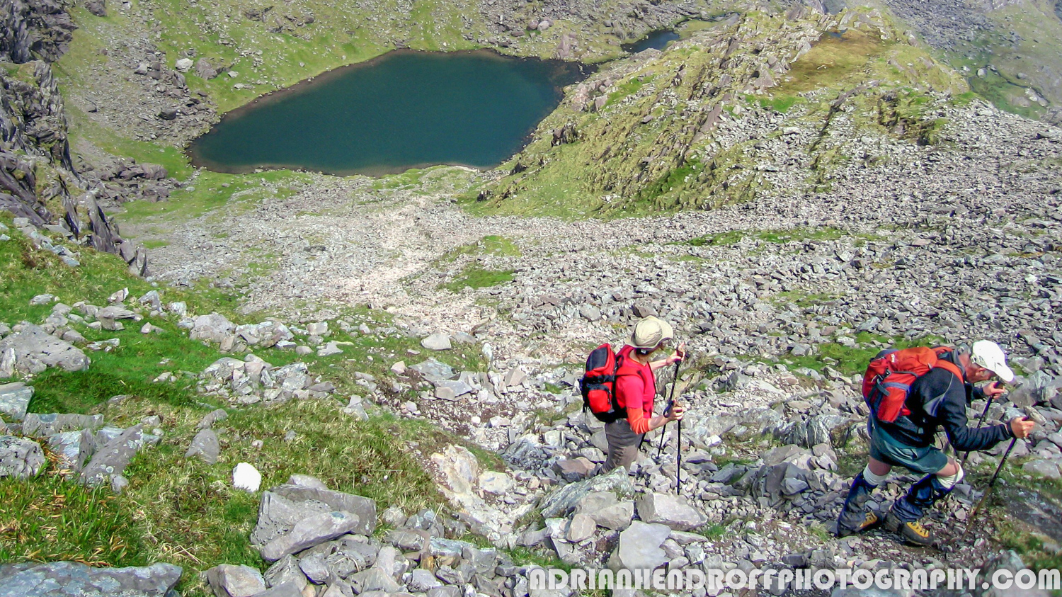
Continue along the river’s right bank to pick up a stony path leading uphill. Lough Gouragh now comes into view and as height is gained Lough Callee can be seen as well. These two lakes found in the Hags Glen are dark and desolate, can you imagine the lives of the six people that once lived here during the Famine. Continue uphill until the path crosses a stream cascading from the crags above. Here the view includes one of Howling Ridge (a classic multi-pitch climbing route) directly above, the crumpled rock of Stumpa an tSaimh and the Reeks ridge farther away to the east.
The Route: Na Teanntaí To O’Shea’s Gully

The path now rises to meet a series of rock steps known as Na Teanntaí: first up are rock ledges leading to a platform above; this is followed by a short, rocky scramble up to a ramp; and lastly a scramble up rock slabs on steep grass. Negotiate these and you’ll find yourself in Cummeeneighter – a hanging valley surrounded by rocky cliffs and a jagged ridge.
Here, a waterfall plunges down from another higher valley. Keep the cascade to your right and follow a scree path under some crags to reach the next level at Cummeenlour. Once you round a corner, O Shea’s Gully appears prominently ahead, along with the narrower and steeper gullies of Central Gully and Curved Gully to its left. All these gullies were formed millions of years ago due to a geological fault causing a massive crack in the earth’s crust.
A path to the left of the cascade leads to the final hanging valley of Cummeenoughter. Here you’ll find the highest lake in Ireland, its dark blue waters flanked by the monstrous cliff faces of Carrauntoohil and Beenkeragh. This is a good place to stop for a rest and lunch before you tackle O’Shea’s Gully which now looms ahead.
The Route: O’Shea’s Gully To Carrauntoohil

O’Shea’s Gully is named after a Christian Brother from Cahersiveen who died in 1968 after falling from the ridge above. Ascend the steep gully with care, it’s full of scree and loose rock. Once you top out, breathe easily and enjoy a panorama that includes Caher and extends from Kenmare Bay to Dingle Bay.
Next, turn left and climb steeply over boulders, passing the tops of Central Gully and Curved Gully, before the slope relents and veers northeast to the summit of Carrauntoohil, decorated by a stone shelter and a cross. The cross was erected in 1976 to replace a timber cross before it. Sometimes on the summit you can be above the clouds and with the rest of the country below you, linger and enjoy the stupendous view.
The Route: Carrauntoohil To The Zig Zags

From the summit descend initially south-southwest and then veer southeast toward the col at the top of the Devil’s Ladder. Be careful not to descend southwest toward Caher, which heads a different direction. Even more importantly, if you come across a “Turn Back Now” sign – stop! The sign warns walkers off attempting any descent route down Howling Ridge, where a fall can be fatal.
Once at the col on top of the Devil’s Ladder, ascend southeast to the grassy top of Cnoc na Toinne (845m/2,772ft). Once on its flat top continue for around 350m to reach a small pile of rocks (Grid Reference V 814 835) that marks the start of the Zig Zags.

The Route: The Zig Zags To The Hag’s Glen
The Zig Zags is a steep path that does what it says on the tin, descending in a snake-like fashion to the base of the Devil’s Ladder. Once at the bottom, you are safe from the clutches of the steep mountainside: follow a stream on the left then later veer away and follow a defined path down to the Hag’s Glen. The glen is said to be the abode of An Cailleach, a powerful Celtic goddess. When the path crosses the Gaddagh River simply retrace your steps back to Cronin’s Yard.
Ready For The Mountain?
This is a big mountain and a serious walk; you’ll need a good head for heights. Regardless of whatever App you use, you’ll need good map and compass skills. Carrauntoohil often has its own micro-climate resulting in low clouds and/or mist. Remember most accidents happen on the way down and in poor visibility it is imperative you take the correct descent route. Wear good hiking trousers (no jeans) and even in the summer, bring along a warm hat and gloves. Also make sure you pack an extra fleece layer and waterproofs just in case it rains. You’ll need good boots to do this hike, ideally 3-4 season ones with good ankle support. Carry a headtorch, a packed lunch and sufficient liquids to drink. Bring along a fully charged mobile phone and if you have to call for Mountain Rescue ring 999 or 112. It is not advisable to attempt this route in strong winds or gales. Always take note of the time it gets dark (this depends on the time of the year) and plan when you start accordingly: this route takes 6 to 7 hours including breaks. In winter, under snow and ice conditions, this route becomes a serious mountaineering venture requiring the use of crampons and ice-axes.
Forecasting The Weather
The temperature at the summit can be up to 10°C colder than at Cronin’s Yard, and colder still if you add any wind-chill. The Kerry weather is influenced by changeable Atlantic weather systems, so check the forecast on the morning of your walk and be equipped for all conditions. Forecasting the weather is a bit of a specialist subject for me. I’ve come up with the knack of getting the forecast nailed over the years – as a photographer who climbs I need the conditions spot on to come away with the best images. My advice is to use yr.no – use the website not the App and always look at the latest update. Look up ‘Carrauntoohil’ there and dive into the detailed, hour-by-hour forecast – this gives you all the important information like cloud cover, the wind-chill factor, precipitation and wind speeds. Apart from yr.no, the met.ie Rainfall Radar and Atlantic Charts are also useful.
About The Blogger
Adrian Hendroff is a member of the Outdoor Writers & Photographer’s Guild and a Mountaineering Ireland approved course provider. He is a fully-insured mountain guide and runs regular navigation and Mountain Skills courses. Adrian has written several Irish walking guidebooks for the Collins Press and is a regular contributor to newspaper/magazine features. He also runs outdoor photography workshops. More on Adrian see www.adrianhendroff.com or www.fabulousviewpoints.com
