-
What’s New in HiiKER: 3D Flyovers, a Redesigned Map & GPX for Recordings
Our biggest update in a while: watch cinematic 3D Flyovers of your hikes and recordings, enjoy a redesigned map, and use GPX with your recordings — plus custom tags, lock-screen recordings on iPhone, and a stack of fixes.
-
DRiiVER: Introducing Auto app by HiiKER
Meet DRiiVER — your driving companion for every adventure. Built by the team behind HiiKER, it brings the same beautiful maps you love, now with turn-by-turn driving routes to trailheads, towns, viewpoints, and anywhere else you’re headed.

-
What’s New in HiiKER — July 2026
Export your routes in any format, lock the screen on the trail, smoother 3D previews and better offline — a round of updates landing on both iPhone and Android.
-
HiiKER named Best in Test by The Great Outdoors 🏆
Right, this is a good one. The Great Outdoors Magazine, the UK outdoor magazine that’s been independently testing gear for 40+ years, has named HiiKER the Best in Test hiking app in its 2026 round-up. Best in Test. Ahead of a field that includes OS Maps, Gaia GPS, Topo GPS, MapOut, Komoot and Outdooractive. For…

-
What’s New on iOS: Mark Hikes Complete, 3D Previews & More Offline
Our latest iOS update lets you track the hikes you’ve completed, preview routes in 3D right from the hike overview, and take even more with you offline — plus smarter search and handy new quick actions.
-
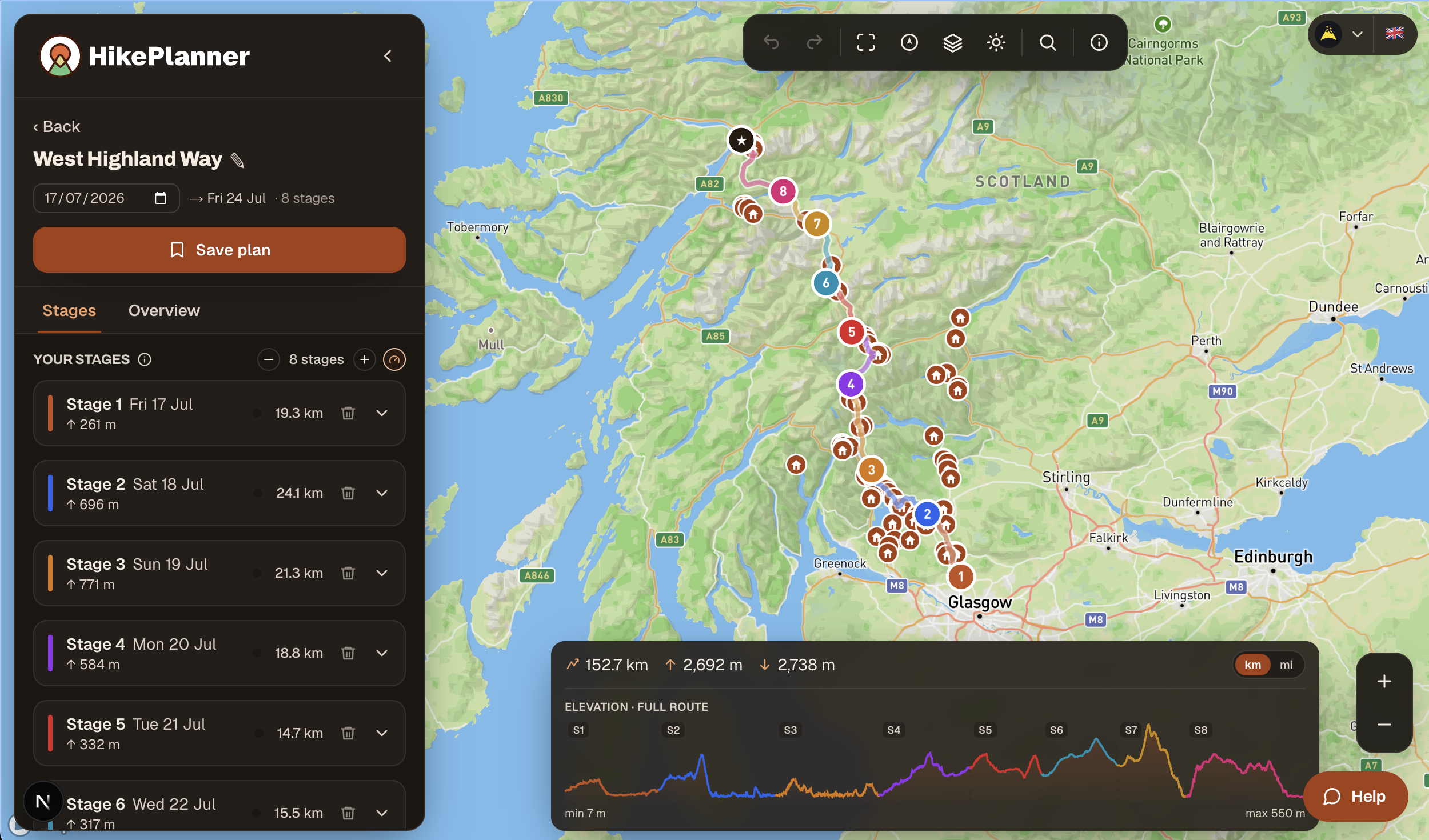
Hike Planner: The Free Tool That Maps Your Multi-Day Hike to the Last Mile
Anyone who has organised a multi-day walk knows the planning rarely happens on the trail. It happens at the kitchen table, weeks beforehand, surrounded by browser tabs, a half-finished spreadsheet, and a map app that was never built for thru-hiking. You’re trying to split a route into sensible days, work out where you’ll sleep each…
-
What’s New in HiiKER — June 2026
A huge month — Android Auto launches, QR sign-in and in-app subscription management arrive on both apps, and iPhone catches up with completed-hike tracking and lots more offline.
-
HiiKER named “Best in Test” by The Great Outdoors — ahead of OS Maps
We’re delighted to share that HiiKER has been named Best in Test in the July 2026 issue of The Great Outdoors, the UK’s original mountain magazine, coming out ahead of OS Maps, MapOut, Topo GPS and a strong field of navigation apps. The review was carried out by TGO contributor James Roddie, who tested the…

-
Plan Your Route, Walk It Offline: HiiKER Teams Up with Cotswold Way Guide and TMB Trail Guide
HiiKER now integrates with Cotswold Way Guide and TMB Trail Guide, letting walkers bring personalised itineraries into the app for reliable offline navigation on trail.
-
Looking for an OS Maps Alternative? Why HiiKER Goes Further
HiiKER beats OS Maps in the UK: same OS Explorer and Landranger maps, plus Harvey, Purple Lizard, in-app historical layers and a real Apple Watch app — £5 cheaper a year. And it works in the Republic of Ireland, where OS Maps stops.