
This update is rolling out now — grab it from the App Store or Google Play.
This round is all about seeing your own hiking story and getting your routes into HiiKER faster. There’s a brand-new stats screen on both apps, a community Heat Maps overlay on Android, GPX imports straight from your lists, and a long list of fixes. Here’s what’s new.
📊 My Stats — your hiking year at a glance
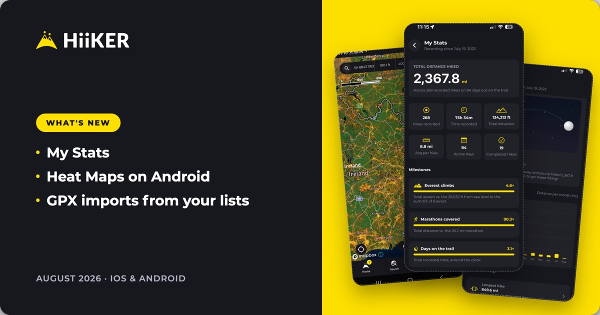
The My Stats page has landed in the apps — the stats you’ve had on the web, now on your phone. It opens on your total distance hiked since the day you started recording, then breaks it all down:
- Your totals — hikes recorded, time out, total elevation, average per hike, active days and completed hikes.
- Milestones — how many times you’ve climbed the height of Everest, how many marathons you’ve covered, and how many full days you’ve spent on the trail.
- Journey to the Moon — how far along the 238,855 miles to the Moon your hiking has carried you so far. Keep going.
- Last 12 months — distance per month, so you can see your seasons at a glance.
- Personal bests — your longest hike, biggest climb and longest time out, each one tappable to jump straight to that recording.
- Year by year — a full table of hikes, distance, elevation and time for every year you’ve been recording, with an all-time total at the bottom.
Everything follows your unit preference, so if you think in miles and feet, that’s what you’ll see.


🔥 Heat Maps on Android — see where hikers actually walk
There’s a new Heat Maps overlay on Android, built from the community’s recorded hikes. It lights up the paths people genuinely walk — the well-trodden routes, the popular loops, and the tracks that never make it onto a standard map. Find it first in the list under Options → Overlays → Data Overlays.
Free members can explore the heat map zoomed out; PRO members get it at every zoom level.

📥 Import GPX files straight from your lists
Got a folder of GPX files? You can now import them from the top of your Hikes and Recordings lists — no need to dig through menus. Pick as many files as you like and HiiKER creates one hike or recording per file, so a whole backlog can come across in one go.

✏️ Edit your hike details on iPhone
You can now edit the details of hikes you’ve created directly from the hike overview — fix a name, tidy up a description, or correct the details after the fact, without starting over.
⚠️ Trail closure warnings
When a trail has a reported closure, you’ll now see a clear warning banner right at the top of the hike overview — so you find out before you drive to the trailhead, not at the gate.

🗺️ Map & overlay improvements
- The overlays picker order now matches the web app on both apps, with Heat Maps first — so it’s the same list wherever you plan.
- On iPhone, your own trails now draw above HiiKER’s trails, so the routes you’ve completed or added stay visible instead of being hidden underneath.
- On iPhone, the app remembers the hike map as your last-opened screen, so you come back to where you left off.
- In the Android planner, the multi-day hike alert now has a proper “Don’t show again” — dismiss it once and it stays dismissed.
- Print maps no longer use Lidar data, for cleaner, more readable printouts.

🎙️ Recording tweaks
- You can now discard a recording straight from the save screen — with a clear confirmation first, so nothing goes by accident.
- On iPhone, recordings stuck waiting to upload can be retried instead of sitting there.
- Clearer wording on the rate-and-save step on Android.
💳 Resume a paused subscription
If you’ve paused your PRO subscription, you can now resume it from inside the app whenever you’re ready — no waiting for the next billing cycle, no emailing support.
🔔 Notifications that ask at the right time
We’ve reworked notification opt-in on both apps. Your app and system notification settings now stay properly in sync, and if you’ve turned notifications off, we’ll only ask again at a genuinely useful moment — with a cooldown so you’re never nagged.
🐛 Fixes & polish
📱 On iPhone & iPad
- GPX import now works offline, with one card per file so you can see exactly what’s coming in.
- Your Recordings list refreshes automatically after an import.
- The recording Live Activity clock keeps counting after you quit and relaunch the app.
- Tapping a waypoint from the list no longer leaves the list sheet stuck open.
- Returning Apple/Google sign-in users go straight to the home screen instead of repeating onboarding.
- Fixed requests occasionally getting stuck while signing in.
🤖 On Android
- Flyover videos now only save to your gallery when you actually tap Save video.
- Offline downloads no longer start twice for the same area.
- The Heat Maps upgrade prompt no longer overlaps the map controls.
- Tidier location-permission prompts — we only ask where it’s genuinely needed.
- Dropped a stray “US” from the Public Access overlay label, and refreshed its legend.
As always, this update is shaped by your feedback — keep it coming. Happy hiking! ⛰️