Prince William’s Seat… now that’s a noble sounding hill. Some say the origin of its name is attributed to the visit of the English monarch King George IV in 1821 or William III around 130 years earlier. But a huge granite tor around a kilometre-and-a-half to the west of its summit might suggest otherwise. Known locally as Fitzwilliam’s Seat, this weathered tor has enough room for several people to sit on. It was named after the Fitzwilliam clan, owners of these lands in the sixteenth and seventeenth centuries, as this was where group members would rest during hunts with their dogs. Fittingly, the summit close to this tor is known as Knocknagun (meaning ‘hill of the hounds’), probably a variation or corruption of Cloghnagun which means ‘rock of the hounds’.

In the 1830s, a detailed survey of Wicklow was conducted from the summit of Prince William’s Seat, and the British Ordnance Survey sappers back then may have been aware of Fitzwilliam’s Seat and could have well replaced the ‘Fitz’ with ‘Prince’. Regardless, its top straddles the Dublin and Wicklow border and rewards the visitor with fine vistas across both counties. Both Prince William’s Seat and Knocknagun are both classified by MountainViews as an Arderin, an Irish summit of over 500m and 30m prominence, of which there are 405 in total.

This route will take you through thick forest to a heathery hillside and open moorland. You’ll be following Wicklow Way (a 131km/81 miles long distance trail from Marlay Park in Dublin through County Wicklow and ending in Clonegal village in Carlow) signposts at the start before visiting the aforementioned 500m+ summits.

Where To Park
Leave your car at Curtlestown Woods car-park (Grid Reference O 185 168) – you’ll find it around 5km away from Enniskerry village in the direction of Glencree.
The Way Up
Follow the Wicklow Way signpost uphill, initially on a broad track flanked by tall Scots pine trees and clumps of bracken, with the latter turning reddish-brown in the autumn. The track soon swings to the right and after a switchback you will be above the tree-line with some hills now appearing on the left and the conical shape of the Great Sugar Loaf featuring prominently behind.
After the next bend keep left at a fork, while still following the Wicklow Way which is signposted by a yellow arrow and walking person symbol. The track is now flanked by a plantation of spruce trees and gorse bushes, whose coconut-scented flowers burst into fiery yellow in the spring. Soon enough you’ll see the rocky outcrop of Carrigaspinkeen perched on the hilltop to the right.
At a crossroad leave the surfaced track and head uphill on a narrow path flanked by more spruce trees and gorse bushes, still guided by Wicklow Way signposts. Some rocky steps soon leads to a clearing on the right giving even better views of Carrigaspinkeen, which is now backed by the Great and Little Sugar Loaf. This section is particularly colourful toward late August when the pink and purple heather are in full bloom which contrast nicely against the bright yellow gorse.

A Little Detour
Once out of the trees, the ground begins to level. Lookout for a subsidiary path on the right leading to a granite outcrop known as Raven’s Rock, a short detour of around 350m. It’s worth doing for the picturesque views toward Knockree Hill, Glencree, Maulin, the Tonduffs and Djouce to the south. Toward the end of August, you’ll find heather flowering abundantly here, covering the slopes in a beautiful pink-purple carpet.

The Summits
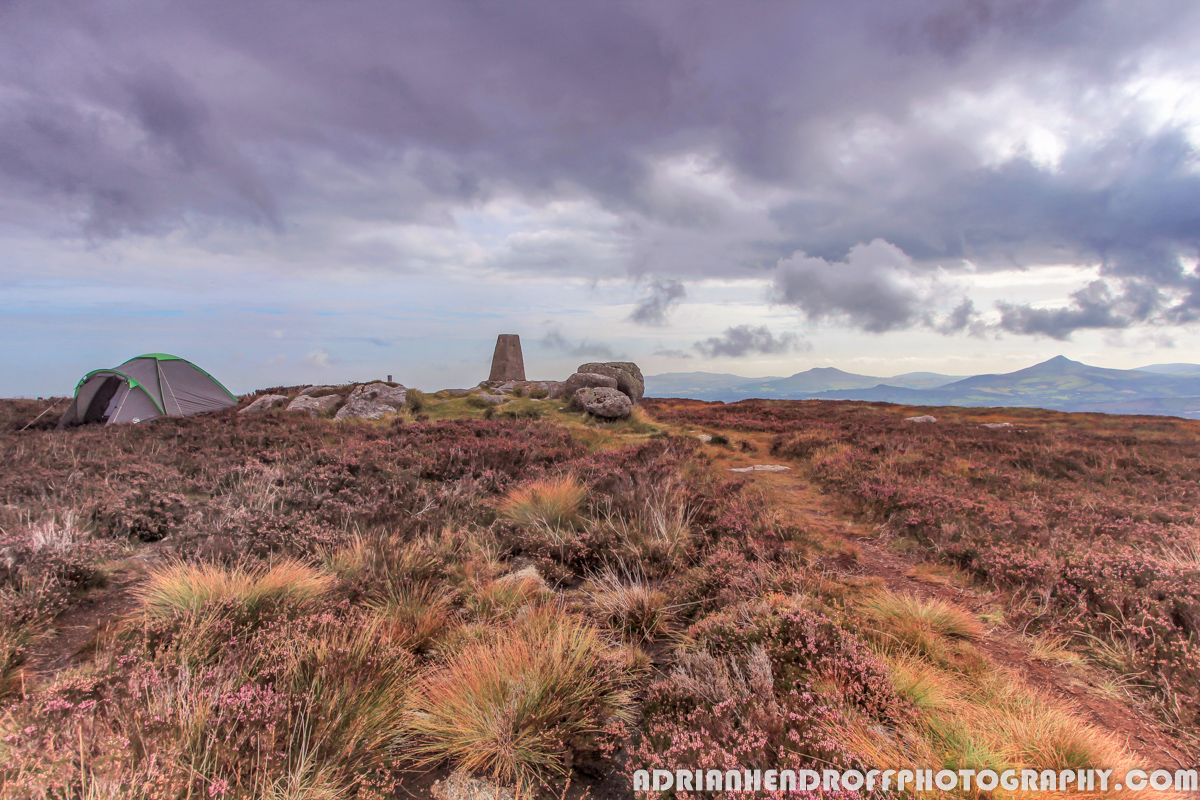
Retrace steps from Raven’s Rock back to the main path then shortly after veer left up a slope on a narrower path. This leads northwest to the summit of Prince William’s Seat, which is marked by a trig pillar amongst a jumble of rocks. Here, the barren Wicklow landscape away to the south contrasts quite profoundly from the grey metropolis of Dublin and its rolling hills in the opposite direction. On a clear day you should be able to see all the popular hills ranging from Kippure to Fairy Castle and the Great Sugar Loaf.

From here you’ll also have an uninterrupted view to the west-northwest toward Knocknagun with a defined path making a beeline to the top. Follow the path down to a broad saddle and shoulder which can be notoriously boggy when wet.
There is no cairn on Knocknagun but near its summit you’ll meet the prominent granite tor of Fitzwilliam’s Seat (Grid Reference O 163 186). The rocky outcrop provides an excellent focal point for landscape photographers but it is the lovely panorama of Wicklow hills to the south that greets the eye, including the communication mast that marks the top of Kippure, with the larger Lower Lough Bray also visible on a clear day.

The Way Down
Descend southwest by following a path for around 350m from Fitzwilliam’s Seat to reach another large outcrop known locally as Castle Toole (Grid Reference O 161 184). This outcrop was once used as a Mass Rock and you’ll find a IHS motif carved into it by the Oblate Brothers from nearby Glencree during the late nineteenth century.
From Castle Toole continue to follow the path down the hill for just over a kilometre to reach a man-made spoil mound known as Oldboleys Quarry (Grid Reference O 151 181). This used to be a site of an old gravel quarry that once provided material for building the Military Road.
Next, turn left onto a narrow track that traces the tree line of a forest plantation on the right (note that a large area of trees may have been felled in recent times). The track undulates and winds its way along the hillside, all the while giving fine views of the Great Sugar Loaf in the distance. After around 1.4km the track veers left and away from the trees, rising to a forest corner (Grid Reference O 165 176). From here, just follow the forest track downhill, which ends with some zig-zags leading down to the car-park at Cloon Woods. Once on the road, turn left and walk for around 1.2km back to the start.
Some Tips
Most of this hike is either on the road, forest tracks or upland paths. However, there is a section running for around 1.5km from Prince William Seat to Knocknagun which can be extremely boggy when wet, so make sure you are wearing good boots and even a pair of gaiters to keep the muck out. Clear weather is a bonus on this hike for both the views and ease of navigation. Wear good hiking trousers (no jeans) and make sure you pack a fleece layer and waterproofs. Around the winter season, pack a woolly hat and gloves too. As with any hillwalk – always pack a map and compass, bring along a fully charged mobile phone and if you have to call for Mountain Rescue ring 999 or 112.
About The Blogger
Adrian Hendroff is a member of the Outdoor Writers & Photographer’s Guild and a Mountaineering Ireland approved course provider. He is a fully-insured mountain guide and runs regular navigation and Mountain Skills courses. Adrian has written several Irish walking guidebooks for the Collins Press and is a regular contributor to newspaper/magazine features. He also runs outdoor photography workshops. More on Adrian see www.adrianhendroff.com or www.fabulousviewpoints.com
