We are thrilled to announce the latest addition to the HiiKER: the new Exmoor map from Harvey Maps. Known for their exceptional accuracy and detail, Harvey Maps are an invaluable resource for hikers exploring the beautiful landscapes of Exmoor National Park. This new map provides comprehensive coverage of the region, highlighting its unique terrain, trails, and significant landmarks.

Explore Exmoor National Park
Exmoor National Park, straddling the counties of Somerset and Devon, is a diverse and scenic area known for its rolling hills, dramatic coastlines, and historic woodlands. The new Harvey Map for Exmoor offers hikers detailed insights into this stunning region, ensuring a safe and enjoyable hiking experience.

Key Landmarks and Points of Interest Covered
Dunkery Beacon


- Elevation: 519 meters (1,703 feet)
- Description: The highest point on Exmoor, Dunkery Beacon offers panoramic views over the surrounding moorland and as far as South Wales on a clear day. It’s a must-visit for anyone hiking in the area.
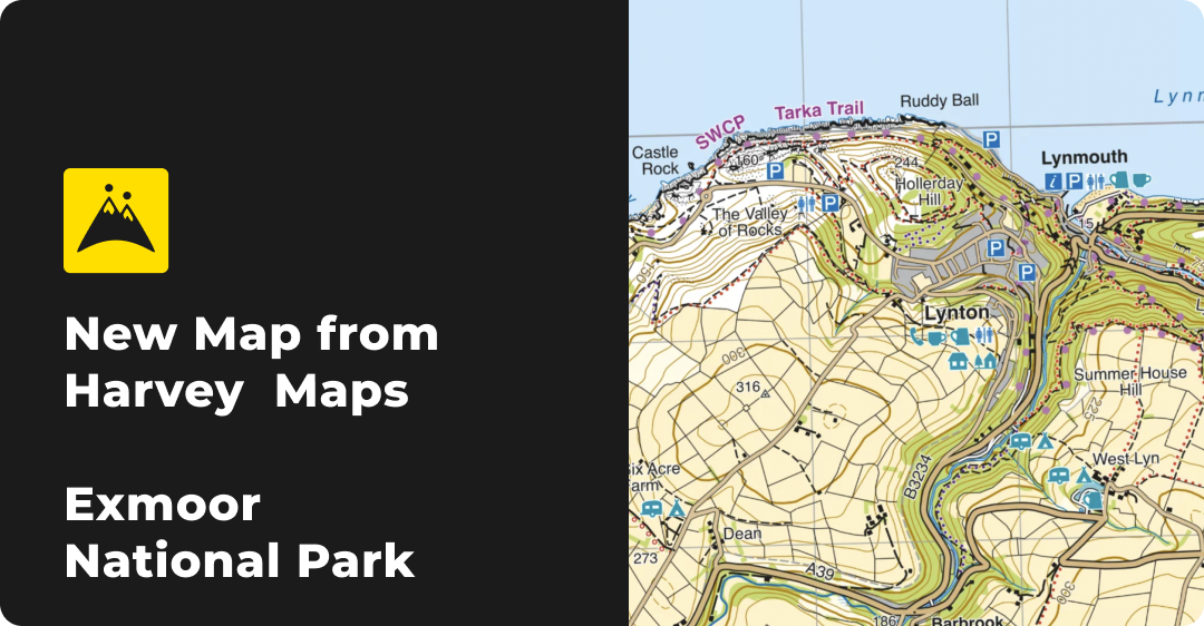
Valley of Rocks


- Description: Located near Lynton, this dry valley is renowned for its dramatic rock formations and wild goats. The Valley of Rocks is a picturesque spot perfect for photography and exploring unique geological features.
Tarr Steps


- Description: This ancient clapper bridge across the River Barle is one of Exmoor’s most iconic landmarks. Surrounded by beautiful woodlands, it’s an ideal spot for a leisurely walk or a picnic.
Heddon’s Mouth


- Description: A stunning coastal area where the River Heddon meets the sea. The hike to Heddon’s Mouth offers breathtaking views of the rugged coastline and opportunities to spot diverse wildlife.
Doone Valley


- Description: Famous for its connection to the novel “Lorna Doone,” this scenic valley provides a tranquil hiking experience through picturesque landscapes and historic sites.
Porlock Weir


- Description: A charming harbour with a rich maritime history, Porlock Weir is a great place to explore the coastal scenery of Exmoor. The area offers a variety of trails with views of the Bristol Channel.
Features of the Harvey Map for Exmoor
- Detailed Contour Lines: Precise elevation information helps hikers understand the terrain, making it easier to prepare for the ups and downs of the landscape.
- Trail Markings: Clear depictions of established paths and routes, including both popular and lesser-known trails.
- Landmark Indicators: Comprehensive details on key landmarks, helping hikers plan their routes to include significant points of interest.
- Facilities and Amenities: Information on nearby facilities such as car parks, restrooms, and picnic areas to assist in trip planning.
Enhance Your Hiking Experience with HiiKER
Integrating the new Harvey Map for Exmoor with HiiKER’s advanced features enhances your hiking adventures:
- Custom Route Planning: Create tailored routes based on the detailed data from Harvey Maps, ensuring each hike is perfectly suited to your preferences and abilities.
- Waypoints: Set and navigate to specific points of interest directly on your Harvey Map within the HiiKER app.
- Offline Maps: Download your maps for offline use, ensuring you have access to crucial navigation tools even in remote areas.
- 3D Visualization: Utilize HiiKER’s 3D map views to get a better understanding of the terrain before you set out.

Exmoor National Park is a treasure trove of natural beauty and historical significance. With the new Harvey Map available on HiiKER, you can explore this magnificent area with confidence and precision. Download the map today and start planning your next adventure in Exmoor National Park.
